Notice
Spatial modeling approach of summer pasture grazing walks / Mélanie Le Couédic
- document 1 document 2 document 3
- niveau 1 niveau 2 niveau 3
Descriptif
Spatial modeling approach of summer pasture grazing walks in an ethnoarchaeological perspective : a pyrenean case study. M. LE COUEDIC (Laboratoire LAT, CITERES, Université François Rabelais, Tours). Deuxième International Workshop on archaeology of european mountain landscape, organisé par les laboratoires GEODE, FRAMESPA, GEOLAB et Chrono-Environnement. Université Toulouse 2-Le Mirail, 8-11 octobre 2009. [Première journée].
Pyrenean summer pastures are mostly a collective resource, used by rural communities of the upper valleys. On a large scale, territorial divisions of these mountains summer pastures are mainly defined by the practice from the shepherd’s huts as the livestock is grazing. To consider these practices and partitions at different periods, based on the pastoral sites documented by archeology, this ethnoarchaeological study aims at understanding the physical and social determinants of herd walks,as well as their material correlates in a spatial perspective. The Pyrenean National Park conducted territory mapping of existing herd walks in the Western Pyrenean summer mountains enables the study of the morphology of these territories according to pastora systems (type of livestock, production, cattle keeping, number of heads) and in terms of environment (orography and vegetation). Then, these territories have borders of various kinds: discontinuous and tight in certain areas, blurred and tangled in others. These variations could show differences in grazing pressure or mode of sharing and access to these areas. Unravel these variations and tackle the physical correlates of walks request to consider these areas on a daily scale, from the huts. From this perspective, the mapping of the Park has been refined by ethnological surveys in the valleys of Ossau and Aspe. These divisions and these areas of cospatiality can thus be understood thanks to the spatial distribution of the huts and with a widening of the perspective to the territorial structuring on valleys scale.
Intervention / Responsable scientifique

Dans la même collection
-
La construction des territoires montagnards : exploitation des ressources et mobilité des pratiques…
GalopDidierThe occupation and the exploitation of mountain environments, both during conquest and maximum demographic phases, or on the contrary, during desertification phases, differ in geographical
-
Human environmental interactions in high altitude zone between Neolithic and roman period / K. Walsh
WalshKevinA History of Transitions : human environmental interactions in the high altitude zone between Neolithic and roman period. Kevin WALSH. In "La construction des territoires montagnards : exploitation
-
L'agro-pastoralisme en milieu montagnard : l'apport des sépultures saisonnières / Patrice Courtaud
CourtaudPatriceL'agro-pastoralisme en milieu montagnard : l'apport des sépultures saisonnières. Patrice COURTAUD. In "La construction des territoires montagnards : exploitation des ressources et mobilité des
-
L'évolution végétale holocène sur le versant sud des Pyrénées occidentales / Maria-José Iriarte
IriarteMaría JoséL'évolution végétale holocène sur le versant sud des Pyrénées occidentales. Maria José IRIARTE. In "La construction des territoires montagnards : exploitation des ressources et mobilité des pratiques"
-
Prehistory of the Southern Appalachian uplands of Tennessee / Jay Franklin
FranklinJay D.Prehistory of the Southern Appalachian uplands of Tennessee. Jay FRANKLIN. In "La construction des territoires montagnards : exploitation des ressources et mobilité des pratiques", 2e International
-
A cultural landscape research in a mediterranean mountain (Barcelona-Girona) / A. Garcia Molsosa
Garcia MolsosaArnauA cultural landscape research in a mediterranean mountain area : the "Massis del Montseny project" (Barcelona-Girona) / A. GARCIA MOLSOSA. In "La construction des territoires montagnards :
-
The Hidram4000 project : land use, human occupation and lanscape changes in Spain / A. Curras
Currás DominguezAndresThe Hidram4000 project : land use, human occupation and lanscape changes in Spain during the last 3000 years. The Somolinos lake record (1240 M A.S.L.) : Siera de Pela, Guadalajara Province. Andres
-
Mountain anthropization in Alps : a multidisciplinary look in the Pygmalion program / F. Arnaud
ArnaudFabienMountain anthropization in Alps : a multidisciplinary look in the framework of Pygmalion research program. Fabien ARNAUD. In "La construction des territoires montagnards : exploitation des ressources
-
Exploitation of natural vegetal resources in chalcolithic areni-1 cave (Armenia) / R. Hovsepyan
HovsepyanRomanExploitation of natural vegetal resources in chalcolithic areni-1 cave settlement (Armenia). Roman HOVSEPYAN ovsepyan, Roman. In "La construction des territoires montagnards : exploitation des
-
Territorial practices, landscape dynamics and mobilities in a french mountain / P. Allée, Y. MIras
AlléePhilippeMirasYannickTerritorial practices, landscape dynamics and spatio-temporal mobilities in a french medium mountain : integrated approach combining archaeological and paleoecological inverstigations performed in the
-
Wildfires in european alps : frequent yesterday, rare today, frequent tomorrow ? / W. Finsinger
FinsingerWalterWildfires in european alps : frequent yesterday, rare today, frequent tomorrow ?. Walter Finsinger. In "La construction des territoires montagnards : exploitation des ressources et mobilité des
-
Exploitation des vallées andorranes depuis le Néolithique/ J.-M. Palet Martinez, H. Orengo Romeu
Palet i MartínezJosep M.Orengo RomeuHèctor A.L'exploitation des ressources des vallées andorranes du Madriu-Perafita-Claror et de la chaîne du Cadi (Pyrénées orientales) depuis le Néolithique à partir des données archéologiques et
Sur le même thème
-
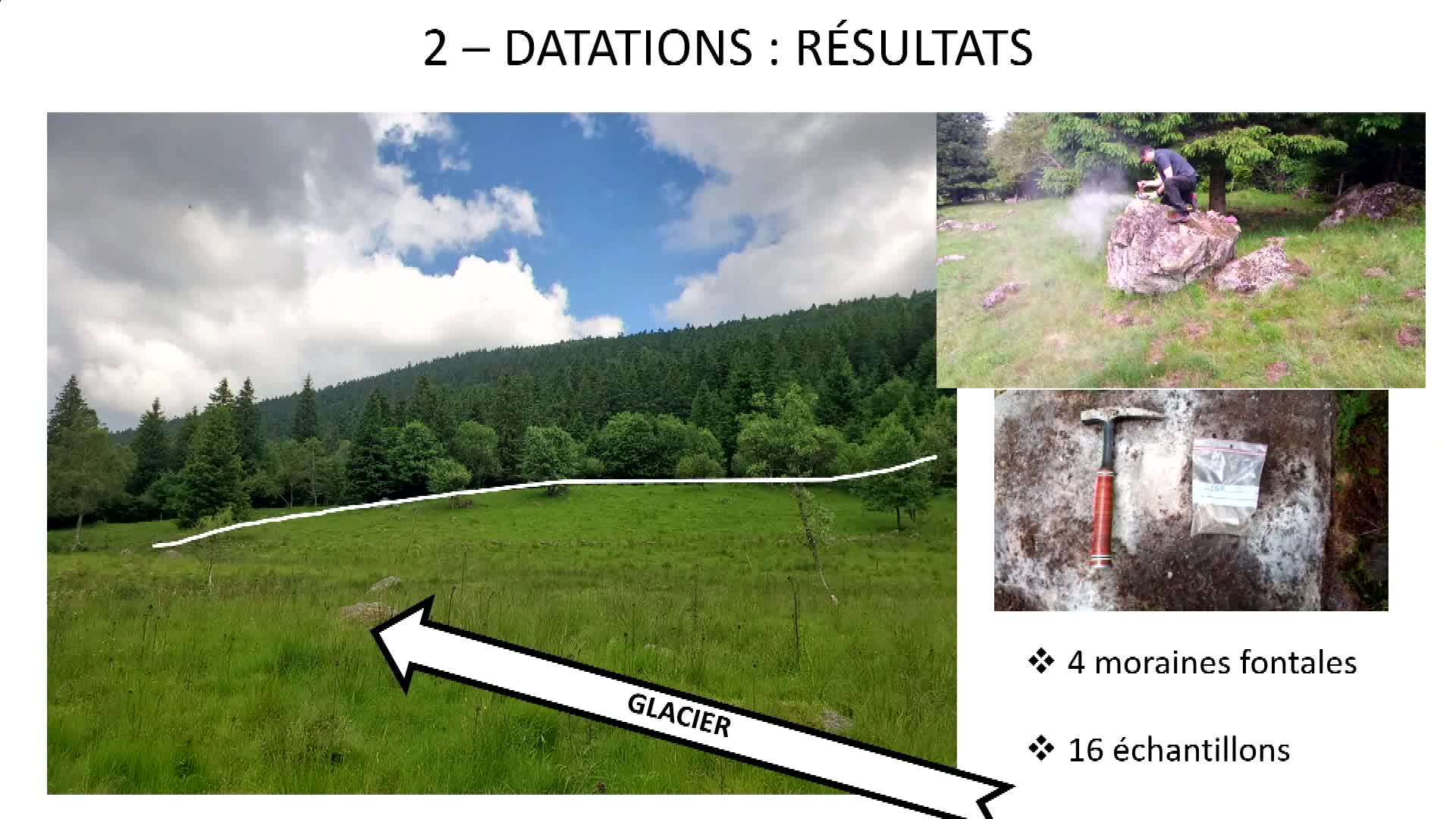
GLAMCE - Dater les paysages glaciaires du Forez : combinaison d’une technique low-tech (Marteau de …
RousselErwanAncrenazArthurArthur Ancrenaz et Erwan Roussel, membres de GEOLAB, présentent le projet GLAMCE.
-
Témoignage de Anca-Cristina Dan
DanAnca-CristinaGuérinAnaëlleDans le cadre de la préparation du 250e anniversaire de son ouverture au public, en décembre 2020, la Bibliothèque interuniversitaire de la Sorbonne (BIS) a mené une collecte d’archives orales afin de
-
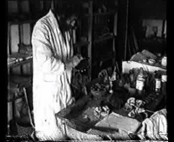
Expérimentation Ethnoarchéologique : La chaine opératoire de la céramique modelée
GaridelYvesYves Garidel présente une partie de ses recherches en ethnoarchéologie expérimentale sur la chaine opératoire de céramiques modelées pré et proto-historiques.
-
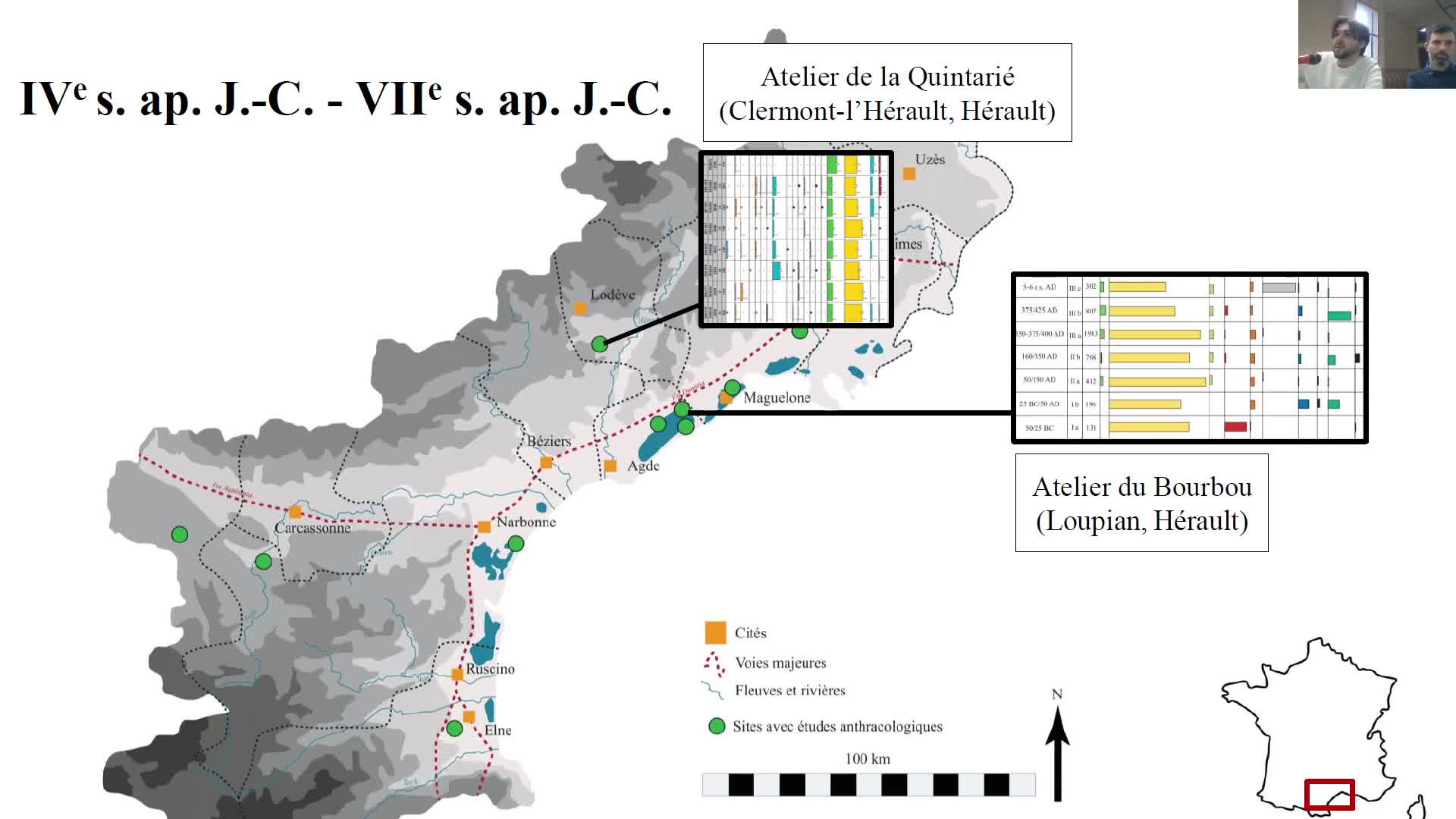
Approvisionner le feu en bois. Regard anthracologique sur l’exploitation du Bois des Lens et les us…
VaschaldeChristopheChardonneau-HenneuseJulienApprovisionner le feu en bois. Regard anthracologique sur l’exploitation du Bois des Lens et les usages du combustible par les potiers de l’Antiquité tardive.
-
Au bon air des jardins. Géohistoire climatique des parcs et jardins urbains (18e-21e siècles), comp…
MetzgerAlexisLes parcs et jardins ont connu à la fois des métamorphoses et une certaine continuité de leurs fonctions écologiques (Mathis et Pépy 2017; Musée historique de Lausanne 2022).
-
-
-
-
-
-
-