Notice
A cultural landscape research in a mediterranean mountain (Barcelona-Girona) / A. Garcia Molsosa
- document 1 document 2 document 3
- niveau 1 niveau 2 niveau 3
Descriptif
A cultural landscape research in a mediterranean mountain area : the "Massis del Montseny project" (Barcelona-Girona) / A. GARCIA MOLSOSA. In "La construction des territoires montagnards : exploitation des ressources et mobilité des pratiques", 2e International Workshop on archaeology of european mountain landscape, organisé par les laboratoires GEODE, FRAMESPA, GEOLAB et Chrono-Environnement. Université Toulouse 2-Le Mirail, 8-11 octobre 2009. [seconde journée]
The present research constitute our PhD Project. It is developped in the ICAC’s Landscape Archaeology team, and its main objective is to obtain a deeper knowlegde of this mountain area as a cultural landscape. The research try to advance in the knowledge of the formation processes of mountain landscapes as a cultural product, and as a result of the socio-environmental interactions. The research is developped in a part of the Catalan prelitoral chain, called “Massís del Montseny”, characterized by an important biodiversity and hard anthropization.
In the poster we present the initial part of the research. In this phase we analize all data that can help us to characterize the human influence in the landscape (archaeological inventories, ethnographical inventories, paleoenvironmental data, ancient cartography). We are also working in the devolopment of GIS Technologies in order to analyze all these information from an spatial perspective. The preliminar data obtained allows us to plan future archaeological works (field"walking, archaeological pits) which will be perform in the next months.
Intervention / Responsable scientifique

Dans la même collection
-
La construction des territoires montagnards : exploitation des ressources et mobilité des pratiques…
GalopDidierThe occupation and the exploitation of mountain environments, both during conquest and maximum demographic phases, or on the contrary, during desertification phases, differ in geographical
-
Human environmental interactions in high altitude zone between Neolithic and roman period / K. Walsh
WalshKevinA History of Transitions : human environmental interactions in the high altitude zone between Neolithic and roman period. Kevin WALSH. In "La construction des territoires montagnards : exploitation
-
L'agro-pastoralisme en milieu montagnard : l'apport des sépultures saisonnières / Patrice Courtaud
CourtaudPatriceL'agro-pastoralisme en milieu montagnard : l'apport des sépultures saisonnières. Patrice COURTAUD. In "La construction des territoires montagnards : exploitation des ressources et mobilité des
-
Prehistory of the Southern Appalachian uplands of Tennessee / Jay Franklin
FranklinJay D.Prehistory of the Southern Appalachian uplands of Tennessee. Jay FRANKLIN. In "La construction des territoires montagnards : exploitation des ressources et mobilité des pratiques", 2e International
-
L'évolution végétale holocène sur le versant sud des Pyrénées occidentales / Maria-José Iriarte
IriarteMaría JoséL'évolution végétale holocène sur le versant sud des Pyrénées occidentales. Maria José IRIARTE. In "La construction des territoires montagnards : exploitation des ressources et mobilité des pratiques"
-
The Hidram4000 project : land use, human occupation and lanscape changes in Spain / A. Curras
Currás DominguezAndresThe Hidram4000 project : land use, human occupation and lanscape changes in Spain during the last 3000 years. The Somolinos lake record (1240 M A.S.L.) : Siera de Pela, Guadalajara Province. Andres
-
Exploitation of natural vegetal resources in chalcolithic areni-1 cave (Armenia) / R. Hovsepyan
HovsepyanRomanExploitation of natural vegetal resources in chalcolithic areni-1 cave settlement (Armenia). Roman HOVSEPYAN ovsepyan, Roman. In "La construction des territoires montagnards : exploitation des
-
Mountain anthropization in Alps : a multidisciplinary look in the Pygmalion program / F. Arnaud
ArnaudFabienMountain anthropization in Alps : a multidisciplinary look in the framework of Pygmalion research program. Fabien ARNAUD. In "La construction des territoires montagnards : exploitation des ressources
-
Territorial practices, landscape dynamics and mobilities in a french mountain / P. Allée, Y. MIras
AlléePhilippeMirasYannickTerritorial practices, landscape dynamics and spatio-temporal mobilities in a french medium mountain : integrated approach combining archaeological and paleoecological inverstigations performed in the
-
Wildfires in european alps : frequent yesterday, rare today, frequent tomorrow ? / W. Finsinger
FinsingerWalterWildfires in european alps : frequent yesterday, rare today, frequent tomorrow ?. Walter Finsinger. In "La construction des territoires montagnards : exploitation des ressources et mobilité des
-
Exploitation des vallées andorranes depuis le Néolithique/ J.-M. Palet Martinez, H. Orengo Romeu
Palet i MartínezJosep M.Orengo RomeuHèctor A.L'exploitation des ressources des vallées andorranes du Madriu-Perafita-Claror et de la chaîne du Cadi (Pyrénées orientales) depuis le Néolithique à partir des données archéologiques et
-
Exemple de l'occupation de l'espace dans la montagne corse au bas Moyen Age: peuplement et économie…
TomasÉmilieExemple de l'occupation de l'espace dans la montagne corse au bas Moyen Age: peuplement et économie dans la Pieve de Rostino. Émilie TOMAS. In "La construction des territoires montagnards :

Sur le même thème
-
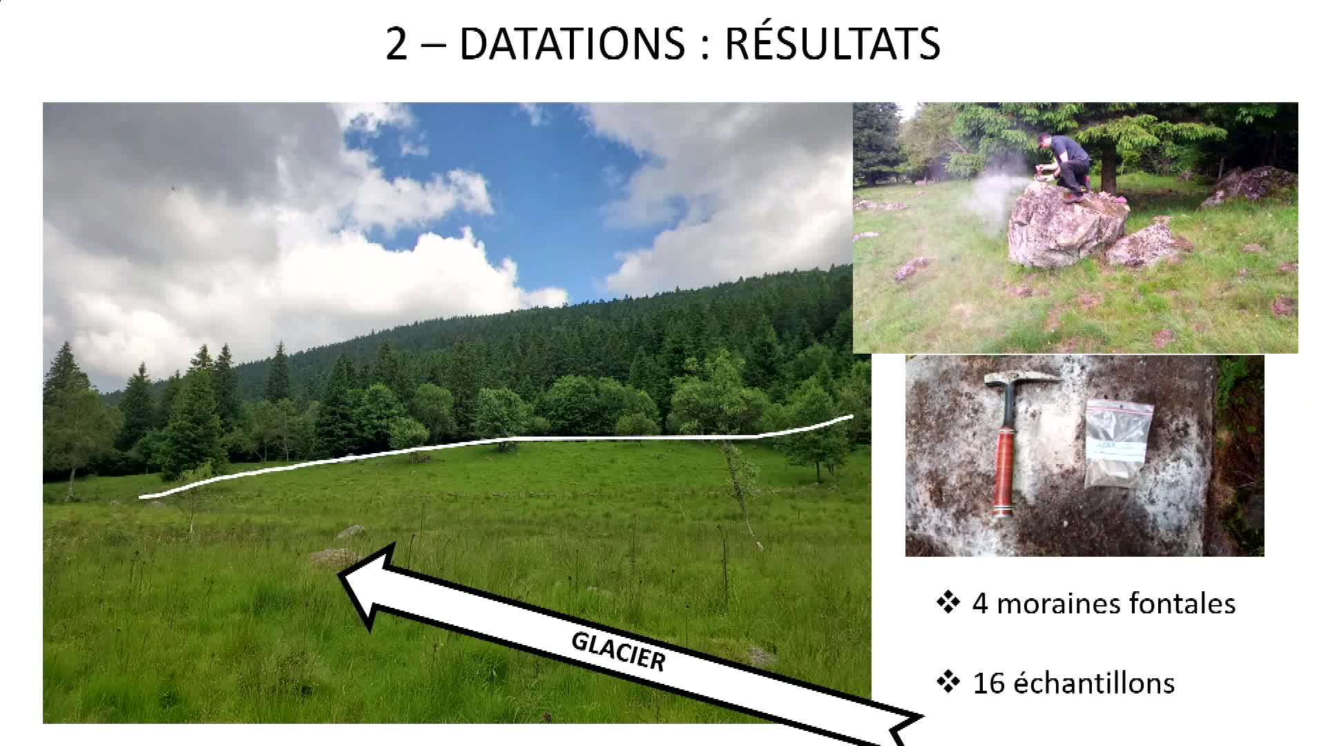
GLAMCE - Dater les paysages glaciaires du Forez : combinaison d’une technique low-tech (Marteau de …
RousselErwanAncrenazArthurArthur Ancrenaz et Erwan Roussel, membres de GEOLAB, présentent le projet GLAMCE.
-
Approvisionner le feu en bois. Regard anthracologique sur l’exploitation du Bois des Lens et les us…
VaschaldeChristopheChardonneau-HenneuseJulienApprovisionner le feu en bois. Regard anthracologique sur l’exploitation du Bois des Lens et les usages du combustible par les potiers de l’Antiquité tardive.
-
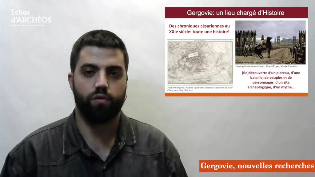
Alfredo Mayoral - « Gergovie : nouvelles recherches géoarchéologiques et paléoenvironnementales »
Le jeudi 16 septembre 2021, à 20h30, sur Facebook, Page Musée de Gergovie, Alfredo Mayoral, géoarchéologue, à l'Institut Catalan d’Archéologie Classique et à GEOLAB (UMR 6042 CNRS / UCA UNILIM), a
-
M. DJAMALI et M. MASHKOUR, Réflexions sur la contribution des coprolithes de hyènes modernes comme …
Réflexions sur la contribution des coprolithes de hyènes modernes comme référentiel pour les reconstitutions paléoenvironnementales. Morteza DJAMALI1, Marjan MASHKOUR2 1-CNRS, IMBE (morteza
-
"Ouranopithecus macedoniensis" (late Miocene, Greece): analysis of mandibular fragments using …
IoannidouMelaniaOuranopithecus macedoniensis (late Miocene, Greece): analysis of mandibular fragments using 3D geometric morphometrics / Melania Ioannidou, in colloque "1st Virtual Conference for Women
-
What is shaping the brain? A perspective on brain size evolution in carnivorans / Margot…
MichaudMargotWhat is shaping the brain? A perspective on brain size evolution in carnivorans / Margot Michaud, in colloque "1st Virtual Conference for Women Archaeologists and Paleontologists. Nouveaux
-
A transdisciplinary approach to reconstruct the Nilotic socio-ecosystem in Luxor west bank during t…
NicatoreGiuliaA transdisciplinary approach to reconstruct the Nilotic socio-ecosystem in Luxor west bank during the Ptolemaic period (3rd-1st centuries BC.) / Giulia Nicatore, in colloque "1st Virtual Conference
-
Neanderthal facing climatic disruptions of the MIS 4 in southwestern France: between cynegetic choi…
DancetteChristelleNeanderthal facing climatic disruptions of the MIS 4 in southwestern France: between cynegetic choices and environmental constraints / Christelle Dancette, in colloque "1st Virtual Conference for
-
Revising the microvertebrates from the Palaeolithic site of Kalamakia (Mani Peninsula), Greece / Ko…
KolendrianouMariaRevising the microvertebrates from the Palaeolithic site of Kalamakia (Mani Peninsula), Greece / Kolendrianou Maria, in colloque "1st Virtual Conference for Women Archaeologists and Paleontologists.
-
Vivre pendant la dernière glaciation. Occupations humaines et paléoenvironnements : quelles spécifi…
LejayMathieuVivre pendant la dernière glaciation. Occupations humaines et paléoenvironnements : quelles spécificités dans les Pyrénées ? Introduction / Mathieu Lejay
-
Environnements glaciaires et fluvioglaciaires dans les Pyrénées au cours de la dernière Terminaison…
DelmasMagaliEnvironnements glaciaires et fluvioglaciaires dans les Pyrénées au cours de la dernière Terminaison glaciaire / Magali Delmas
-
Chronologie des fluctuations glaciaires dans les Pyrénées au cours du Global LGM et de la dernière …
ReixachThéoChronologie des fluctuations glaciaires dans les Pyrénées au cours du Global LGM et de la dernière Terminaison glaciaire : données nouvelles et implications paléo-climatiques / Théo Reixach