Notice
Foragers and their symbolic landscape. Understanding the role of rock art in the territoriality of Later Stone Age Matobo populations / Léa Jobard
- document 1 document 2 document 3
- niveau 1 niveau 2 niveau 3
Descriptif
Foragers and their symbolic landscape. Understanding the role of rock art in the territoriality of Later Stone Age Matobo populations / Léa Jobard, in colloque "1st Virtual Conference for Women Archaeologists and Paleontologists. Nouveaux apports à l’étude des populations et environnements passés" organisé par le laboratoire Travaux et Recherches Archéologiques sur les Cultures, les Espaces et les Sociétés (TRACES) de l’Université Toulouse Jean Jaurès et le laboratoire Paléontologie Évolution Paléoécosystèmes (PALEVOPRIM) de l'Université de Poitiers, sous la responsabilité scientifique de Julie Bachellerie, Ana Belén Galán López (Traces), Émilie Berlioz et Margot Louail (Palevoprim). Université Toulouse Jean Jaurès, 8-9 mars 2021.
Session 2 : Occupation of territories and population mobility.
[Conférence enregistrée en distanciel].
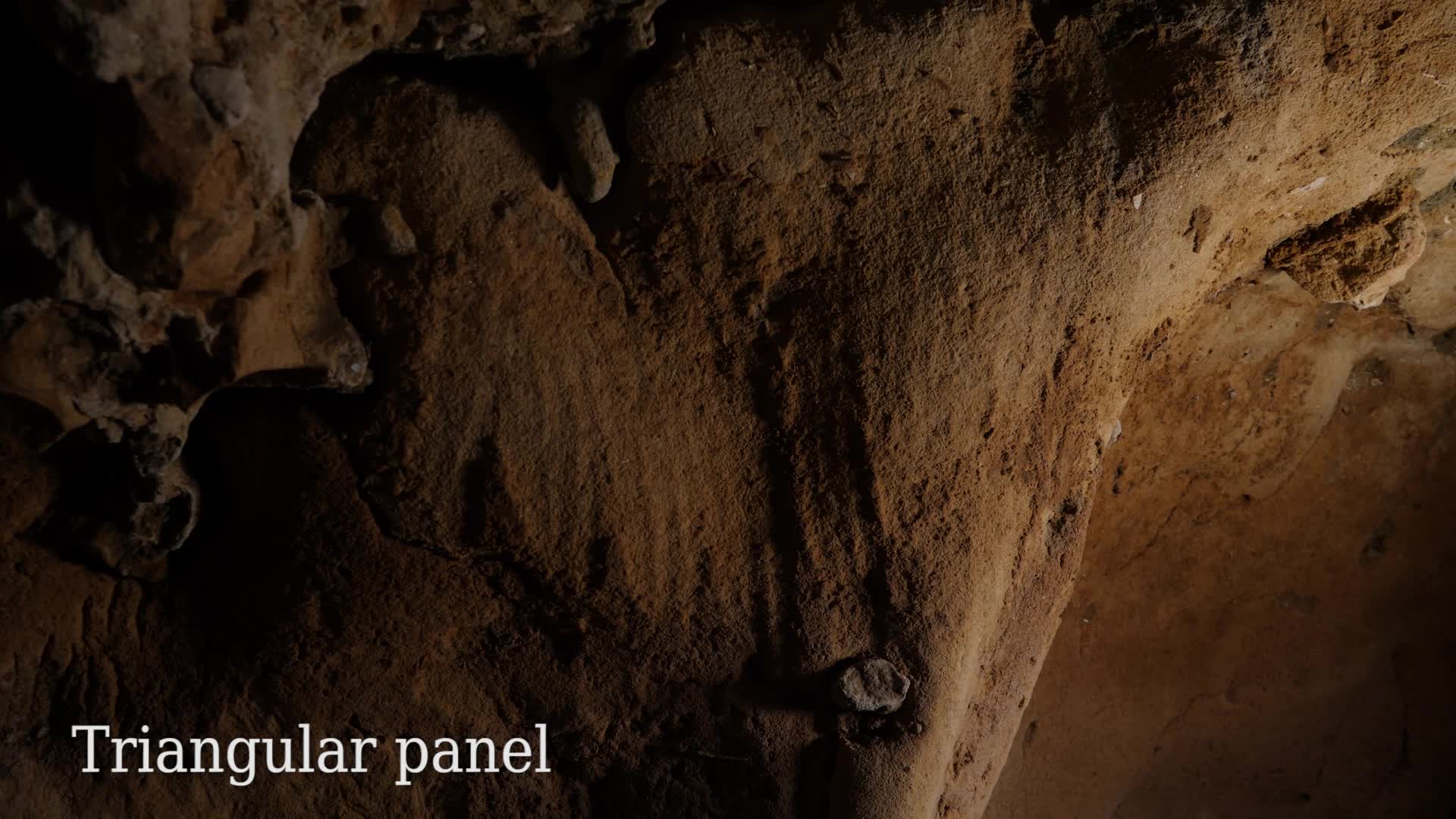
Located in south western Zimbabwe, the Matobo Hills, a UNESCO World Heritage Landscape, is well known for its hundreds of rock art sites, the oldest being 13 000 years old, and a few rich and well-preserved MSA and LSA sequences. These archaeological remains were excavated and documented mostly in the second part of the 20th century, but are still understudied. One of the researchers, Nick Walker, proposed a sequence of settlement patterns by the Middle and Later Stone Age populations, mostly based on socio-economic behaviour, giving little consideration to the symbolic sphere (Walker, 1995).Nonetheless, as a fixed media present in great number in the Matobo, and as anactivity led within a socio- economic context (Robinson, 2010) in highlysignificant places (Deacon, 1988), rock art appears as an essential element tofully understand the Matobo past societies’ landscape investment. Moreover,clearly distinct styles (i.e. technique, theme, form) of hunter gatherer’spaintings are visible in different parts of the Matobo, as well as in the same sites.These images often overlap each other, sometimes forming complex palimpsests. This could be explained by the presence of different hunter-gatherer groups using the same sites, and/orby chronological changes and/or by different uses of rock art, by the same ordifferent groups, – each reason implying a different territorial strategy.Therefore, we wonder what role rock art had in the past social networks and territory structuring, and how it changed. I will first present the general context of the Matobo Hills and the settlement model proposed by Nick Walker, and then explore to which extend rock art can offer a more comprehensive vision of the territory occupation and social relationships in the Matobo Hills.

Thème
Documentation
Références documentaires
JOBARD, Léa, DUDOGNON, Carole, BOURDIER, Camille (dirs) (2020). The Rock Art of the Hunter-Gatherers of Southern Africa / L’art rupestre des chasseurs-collecteurs d’Afrique australe, IFAS, Lesedi Field Notes, 23, 78 p. [En ligne : http://www.ifas.org.za/research/2020/lesedi-23-november-2020/].
WALKER, Nick (2012). The rock art of the Matobo Hills, Zimbabwe, Adoranten, 38-59. [En ligne : https://www.rockartscandinavia.com/images/articles/a12walker.pdf].
ROBINSON, K. R. (1986). A note on the occurrence of goats and sheep in the rock art of North-Eastern Zimbabwe, The South African Archaeological Bulletin, 32-34.
Liens
Programme du colloque "1st Virtual Conference for Women Archaeologists and Paleontologists" (8-9 mars 2021)
Website du Laboratoire Paléontologie Évolution Paléoécosystèmes Paléoprimatologie (PALEVOPRIM)
Livret des résumés des communications du colloque "1st Virtual Conference for Women Archaeologists and Paleontologists. Nouveaux apports à l’étude des populations et environnements passés" (8-9 mars 2021)
Site internet dédié au colloque "1st Virtual Conference for Women Archaeologists and Paleontologists" (8-9 mars 2021)
Dans la même collection
-
Sensivity analysis to morphological changes of the shoulder joint: application to percussio…
BLASI-TOCCACCELI Alicia
Sensivity analysis to morphological changes of the shoulder joint: application to percussion gestures during Oldowan debitage / Alicia Blasi-Toccacceli, in colloque "1st Virtual Conference for
-
"Ouranopithecus macedoniensis" (late Miocene, Greece): analysis of mandibular fragments using …
IOANNIDOU Melania
Ouranopithecus macedoniensis (late Miocene, Greece): analysis of mandibular fragments using 3D geometric morphometrics / Melania Ioannidou, in colloque "1st Virtual Conference for Women
-
Comminution capabilities of extant and fossil anthropoids during molar intercuspation: a preliminar…
WALKER Axelle E. C.
Comminution capabilities of extant and fossil anthropoids during molar intercuspation: a preliminary experiment using a chewing simulator / Axelle E. C. Walker, in colloque "1st Virtual Conference for
-
New sperm whale cranium from the late Miocene and a revised family attribution for the small crown …
ALFSEN Apolline
New sperm whale cranium from the late Miocene and a revised family attribution for the small crown physeteroid Thalassocetus / Apolline Alfsen, in colloque "1st Virtual Conference for Women
-
What is shaping the brain? A perspective on brain size evolution in carnivorans / Margot…
MICHAUD Margot
What is shaping the brain? A perspective on brain size evolution in carnivorans / Margot Michaud, in colloque "1st Virtual Conference for Women Archaeologists and Paleontologists. Nouveaux
-
Postnatal shape changes in the rodent mandible at a macroevolutionary scale / Morgane Dubied
DUBIED Morgane
Postnatal shape changes in the rodent mandible at a macroevolutionary scale / Morgane Dubied, in colloque "1st Virtual Conference for Women Archaeologists and Paleontologists. Nouveaux apports à l
-
Cranial vault healing in modern humans: input of archaeological and clinical data / Aliéno…
LEPETIT Aliénor
Cranial vault healing in modern humans: input of archaeological and clinical data / Aliénor Lepetit, in colloque "1st Virtual Conference for Women Archaeologists and Paleontologists. Nouveaux
-
A transdisciplinary approach to reconstruct the Nilotic socio-ecosystem in Luxor west bank during t…
NICATORE Giulia
A transdisciplinary approach to reconstruct the Nilotic socio-ecosystem in Luxor west bank during the Ptolemaic period (3rd-1st centuries BC.) / Giulia Nicatore, in colloque "1st Virtual Conference
-
From monoliths to megaliths: a new approach on the megalithic burials of southwestern France / Bosc…
BOSCUS Sarah
From monoliths to megaliths: a new approach on the megalithic burials of southwestern France / Boscus Sarah, in colloque "1st Virtual Conference for Women Archaeologists and Paleontologists. Nouveaux
-
Tracing Human Ancestral Migration from its Symbiotic Bacteria / Alexia Nguyen Trung
NGUYEN TRUNG Alexia
Tracing Human Ancestral Migration from its Symbiotic Bacteria / Alexia Nguyen Trung, in colloque "1st Virtual Conference for Women Archaeologists and Paleontologists. Nouveaux apports à l’étude des
-
Towards a tracking of past bird seasonal migrations through geological times: what could isotopes t…
DUHAMEL Anaïs
Towards a tracking of past bird seasonal migrations through geological times: what could isotopes tell us? / Anaïs Duhamel, in colloque "1st Virtual Conference for Women Archaeologists and
-
Study of human group behaviors during the Last Glacial Maximum in the east Carpathian area from zoo…
DEMAY Laëtitia
Study of human group behaviors during the Last Glacial Maximum in the east Carpathian area from zooarchaeological remains / Laëticia Demay, in colloque "1st Virtual Conference for Women Archaeologists


Sur le même thème
-
Décharner, mettre en pièces, fracturer le gibier au Paléolithique : même menu, mêmes façons de fair…
SOULIER Marie-Cécile
BIROUSTE Clément
COSTAMAGNO Sandrine
À destination principalement des étudiantes et étudiants en archéologie ainsi que des archéozoologues, cette journée visait à mettre en lumière la diversité des pratiques de boucherie à travers le
-
Les grandes étapes de l’alimentation, du Paléolithique à l’époque gauloise
FLOUEST Anne
Anne Flouest, géologue et docteure en paléoclimatologie, revient sur l’étonnante évolution des usages alimentaires du Paléolithique à l’époque gauloise.
-
La grotte de La Roche-Cotard
Court métrage réalisé à l'occasion d'une mission dans la grotte de la Roche-Cotard en 2020.
-
"Ouranopithecus macedoniensis" (late Miocene, Greece): analysis of mandibular fragments using …
IOANNIDOU Melania
Ouranopithecus macedoniensis (late Miocene, Greece): analysis of mandibular fragments using 3D geometric morphometrics / Melania Ioannidou, in colloque "1st Virtual Conference for Women
-
Tracing Human Ancestral Migration from its Symbiotic Bacteria / Alexia Nguyen Trung
NGUYEN TRUNG Alexia
Tracing Human Ancestral Migration from its Symbiotic Bacteria / Alexia Nguyen Trung, in colloque "1st Virtual Conference for Women Archaeologists and Paleontologists. Nouveaux apports à l’étude des
-
Study of human group behaviors during the Last Glacial Maximum in the east Carpathian area from zoo…
DEMAY Laëtitia
Study of human group behaviors during the Last Glacial Maximum in the east Carpathian area from zooarchaeological remains / Laëticia Demay, in colloque "1st Virtual Conference for Women Archaeologists
-
New insights into the study of past populations: archeozoology and cementochronology in the Middle …
ROUSSEL Audrey
New insights into the study of past populations: archeozoology and cementochronology in the Middle Palaeolithic / Audrey Roussel, in colloque "1st Virtual Conference for Women Archaeologists and
-
Neanderthal facing climatic disruptions of the MIS 4 in southwestern France: between cynegetic choi…
DANCETTE Christelle
Neanderthal facing climatic disruptions of the MIS 4 in southwestern France: between cynegetic choices and environmental constraints / Christelle Dancette, in colloque "1st Virtual Conference for
-
Aux sources de la préhistoire : Édouard Piette à la terrasse des glaciers / François Bon
BON François
Beaucoup de préhistoriens, et non des moindres parmi ceux qui inventèrent cette discipline au cours du XIXème siècle, répondirent à l’appel de la montagne : quel autre milieu pouvait, mieux qu’elle,
-
Vivre pendant la dernière glaciation. Occupations humaines et paléoenvironnements : quelles spécifi…
LEJAY Mathieu
Vivre pendant la dernière glaciation. Occupations humaines et paléoenvironnements : quelles spécificités dans les Pyrénées ? Introduction / Mathieu Lejay
-
Les paléo-englacements pyrénéens du Maximum Würmien au Global LGM / Marc Calvet
CALVET Marc
Les paléo-englacements pyrénéens du Maximum Würmien au Global LGM / Marc Calvet
-
Environnements glaciaires et fluvioglaciaires dans les Pyrénées au cours de la dernière Terminaison…
DELMAS Magali
Environnements glaciaires et fluvioglaciaires dans les Pyrénées au cours de la dernière Terminaison glaciaire / Magali Delmas